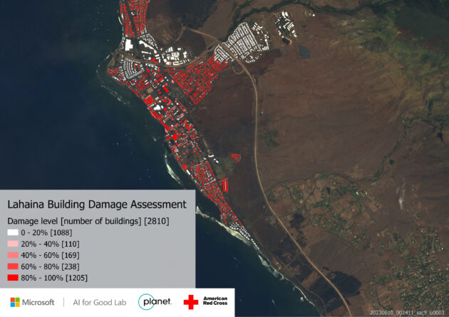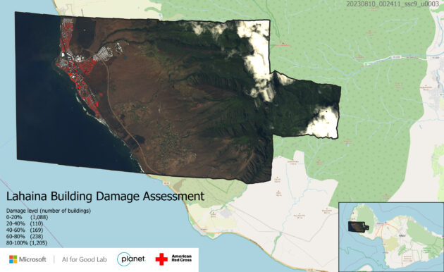
In Maui’s historic town of Lahaina, more than half of the community’s 2,810 buildings have been damaged by a wildfire that this week obliterated the landscape. More than 1,200 of the impacted structures were essentially destroyed.
That’s according to research by Microsoft, which is providing the American Red Cross and other emergency organizations with maps analyzed by AI in order to help guide their response. The satellite images were provided by Planet.
“This is critical because they need to understand where to send people, which areas need to [be] prioritized, which part are they not considering,” said Juan Lavista Ferres, chief scientist and lab director at the Microsoft AI for Good Lab.
Microsoft and other tech companies and their employees are responding to the devastating wildfires in Hawaii, providing tech support and donations of goods and cash. Amazon has donated items such as tarps and coolers and says it will help deliver additional resources as needed. Amazon founder Jeff Bezos and his fiancée Lauren Sanchez announced Friday they are creating a $100 million recovery fund for the island.
“This is critical because they need to understand where to send people, which areas need to [be] prioritized, which part are they not considering.”
– Juan Lavista Ferres, Microsoft’s AI for Good Research Lab
The Microsoft analysis came from a longer-term, larger effort to build tools for detecting damaged buildings and structures. The project uses AI to compare before-and-after satellite images to identify damage and the percent of damage. It can be applied to wide-ranging natural disasters such as wildfires, floods, hurricanes and volcanic eruptions.
Analysis of the human-caused destruction in Russia’s war in Ukraine helped improve the tool, Lavista Ferres said. Microsoft was working in partnership with United Nations’ efforts.
Unfortunately, the need for the resource is widespread.
“When we started working on this two years ago, every single organization that we talked to, they needed this exact same tool,” Lavista Ferres said.
A four-person team at the Redmond-based software giant worked to generate the images for Maui’s emergency responders.
Members of the AI for Good team are working on other wildfire-related projects as well. One initiative is tackling wildfire predictions based on information such as where past fires have occurred. The goal of that effort is to direct wildfire prevention efforts, which could include actions such as prescribed burns, and to prioritize where firefighting resources are allocated.
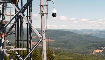
The engineers are also working on AI tools for quickly detecting wildfires using images from satellites and cameras installed in wildfire-prone areas. AI can monitor vast quantities of images around the clock, searching for smoke or flames.
Wildfires are typically extinguished by creating nonflammable boundaries that contain them, and the blazes burn themselves out. Detecting fires and creating those borders quickly are key to limiting damage.

Other companies and organizations are also harnessing the computational power of AI to address the growing problem of wildfires, which are complex and fast-moving events.
The state of Washington recently began piloting services provided by Pano AI, a San Francisco company that uses AI-assisted cameras to spot fires. The Pacific Northwest National Laboratory (PNNL) developed RADRFIRE, a tool using infrared satellite imagery and AI to create detailed wildfire maps to track and forecast fires. Seattle-area startup Data Blanket is developing AI-based drone system for surveying fires to map their perimeters and direct resources.
Microsoft currently shares its wildfire tools with interested organizations. The plan is to eventually release them as open source for anyone to use. The work is funded internally by Microsoft.
“It is really rewarding to try to use this data to help, to see how these organizations are using that data and making them more efficient,” Lavista Ferres said. “It’s actually a great experience for us.”
Related coverage:
Wildfire startup puts AI-powered eyes in the forest to watch for new blazes and provide rapid alerts


